Uptown 23rd & Western Avenue, Oklahoma City, OK
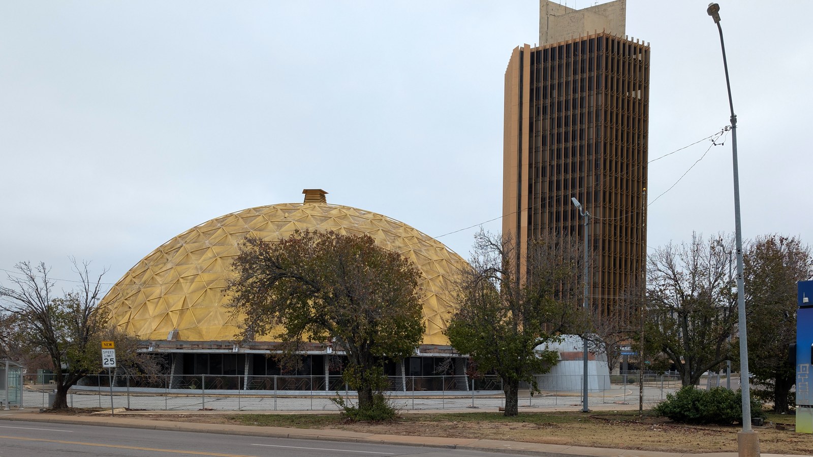

What Uptown 23rd & Western Avenue is actually like
NW 23rd Street runs along the historic alignment of Route 66, and the corridor between Broadway and Pennsylvania avenues carries the landmarks to prove it: the Gold Dome, a geodesic-dome former bank built in 1958, and the Milk Bottle Grocery, an actual milk-bottle-shaped building dating to 1910, both sit along the stretch, with Oklahoma City University anchoring the corridor's western end (Uptown 23rd District). Western Avenue, running roughly from NW 30th to Wilshire Boulevard, developed as its own separate commercial strip immediately south of the independent suburb of Nichols Hills, serving that enclave's shoppers without ever being part of it (Wikipedia).
Both corridors needed real intervention to reach their current state. The Uptown 23rd District Association organized as a 501(c)(4) nonprofit in 2012 specifically to restore the NW 23rd corridor, partnering with the University of Oklahoma's Institute for Quality Communities on a stakeholder-driven improvement plan built around one explicit goal: making the street "a place to drive to, instead of a place to drive through" (Uptown 23rd District). Western Avenue built its own identity around a different anchor: Bishop McGuinness High School and, more recently, Chesapeake Energy's corporate campus, both landmarks along the corridor today (Wikipedia).
The revival shows up in real Walk Score numbers: a location at NW 23rd and Dewey, on the Uptown 23rd corridor's border with the historic Mesta Park neighborhood, scores 89 ("Very Walkable"), the third-most-walkable point Walk Score has measured anywhere in Oklahoma City (Walk Score). A separate point on Western Avenue at NW 36th Street scores 76 ("Very Walkable") with a 64 Bike Score (Walk Score) -- both genuinely strong numbers for a metro whose citywide baseline is a car-dependent 34.
Home values in Uptown 23rd & Western Avenue
Zillow's Home Value Index for ZIP 73118, covering the Western Avenue corridor and surrounding blocks, was $236,625 as of August 31, 2026, up 0.1% year-over-year (Zillow) -- note that this ZIP covers the broader residential area around the corridor, not just the commercial strip itself, so treat it as a neighborhood-scale figure rather than a price specific to the storefronts along 23rd or Western. Oklahoma's tax structure is genuinely different from the no-income-tax states this site has built in recently: the state levies a personal income tax with three brackets topping out at 4.5% (Tax Foundation), on top of which Oklahoma City's own combined sales tax runs 8.625% (4.5% state plus 4.125% city) (Avalara). Property taxes run the other direction: Oklahoma's statewide average effective property tax rate is 0.80% (26th-highest nationally), though Oklahoma County itself runs a bit above that state average at roughly 0.97%. The state's homestead exemption is modest by design -- a flat $1,000 reduction in a primary residence's assessed fair cash value, not a percentage or dollar-amount cap like Florida's -- with a separate, larger assessed-value freeze available to homeowners 65 or older or with a qualifying disability and household income under $25,000 (PropertyTaxByState.com). That risk shows up directly in insurance costs: Oklahoma homeowners insurance is projected to average around $5,858 a year in 2026, nearly double the roughly $3,057 national average, making Oklahoma the second most expensive state for homeowners insurance despite having no hurricane coastline at all. Hail, not tornado wind directly, is the bigger day-to-day claims driver -- Oklahoma saw 767 hailstorms in 2024, third-most nationally, and each one can generate roof claims across an entire metro area at once -- and the state's homeowners insurance rates rose 24% in 2025 alone as carriers priced that in (Live Insurance News).
Getting around
This is one of the more genuinely walkable corridors in Oklahoma City -- the 89 Walk Score near NW 23rd and Dewey and the 76 near Western and NW 36th are both real, sourced numbers, not outliers. Neither street sits on the streetcar line, so reaching downtown or crossing between the two corridors still means a car or an EMBARK bus, but errands within either strip itself are genuinely walkable by Oklahoma City standards.
Uptown 23rd & Western Avenue FAQ
Is Uptown 23rd walkable?
Yes -- a location at NW 23rd and Dewey, on the corridor's border with Mesta Park, scores 89 on Walk Score ("Very Walkable"), one of the highest points Walk Score has measured anywhere in Oklahoma City, against a citywide baseline of 34.
What is the Gold Dome?
A 1958 geodesic-dome building at NW 23rd and Classen, originally built as Citizens State Bank -- only the fifth geodesic dome ever built anywhere and the first used as a bank. It's a well-known Route 66 landmark and sits right at the edge of both the Uptown 23rd and Asian District corridors.
Is Uptown 23rd/Western Avenue part of Nichols Hills?
No -- Western Avenue's commercial strip runs immediately south of Nichols Hills, an entirely separate, independently incorporated suburb, and serves as its commercial edge without being part of it. Nichols Hills itself is covered in a separate guide.
What's the story behind the Milk Bottle Grocery building?
It's a real 1910 building shaped like a milk bottle, at NW 23rd and Classen, and it unofficially marks the entrance to the Asian District immediately east of Uptown 23rd -- one of Oklahoma City's more recognizable Route 66-era landmarks.
Does this area flood?
No -- NW 23rd and Western Avenue both sit on higher ground several miles north of the Oklahoma River's channelized floodplain. The dominant severe-weather risk here, as across the metro, is tornado season, which runs roughly April through June.
How much do homes cost here?
Zillow's Home Value Index for the ZIP covering Western Avenue and the surrounding blocks was $236,625 as of August 31, 2026, essentially flat year-over-year at up 0.1%.
Nearby alternatives*We're not ranking these — every place has real trade-offs, and which ones matter is up to you.
Plaza Paseo Asian District
Immediately east along NW 23rd and Classen -- the Gold Dome sits right at the seam, with the Asian District's restaurants and the Paseo's galleries a short walk or drive further in.
Midtown Automobile Alley
A few miles south via Classen or Walker -- closer to downtown, with the OKC Streetcar's Midtown stop this corridor itself lacks.
Bricktown Downtown
About 3 miles south -- the metro's civic and entertainment anchor, and the destination most drives from this corridor are ultimately headed toward.
Compare Uptown 23rd & Western Avenue to these side by side →
See what makes Oklahoma City stand out — verified, named medical, dietary, sports, and other specialty resources you won't find in most metros.
Explore Specialty Resources →